VarioBud app icon — a pilot under a rainbow paraglider wing

VarioBud

Your variometer's best buddy in the sky.

Read your vario at arm's length, find the lift, know the airspace before you reach it — and land with the flight already logged. All on the iPhone already in your harness.


Currently in final development for public release.
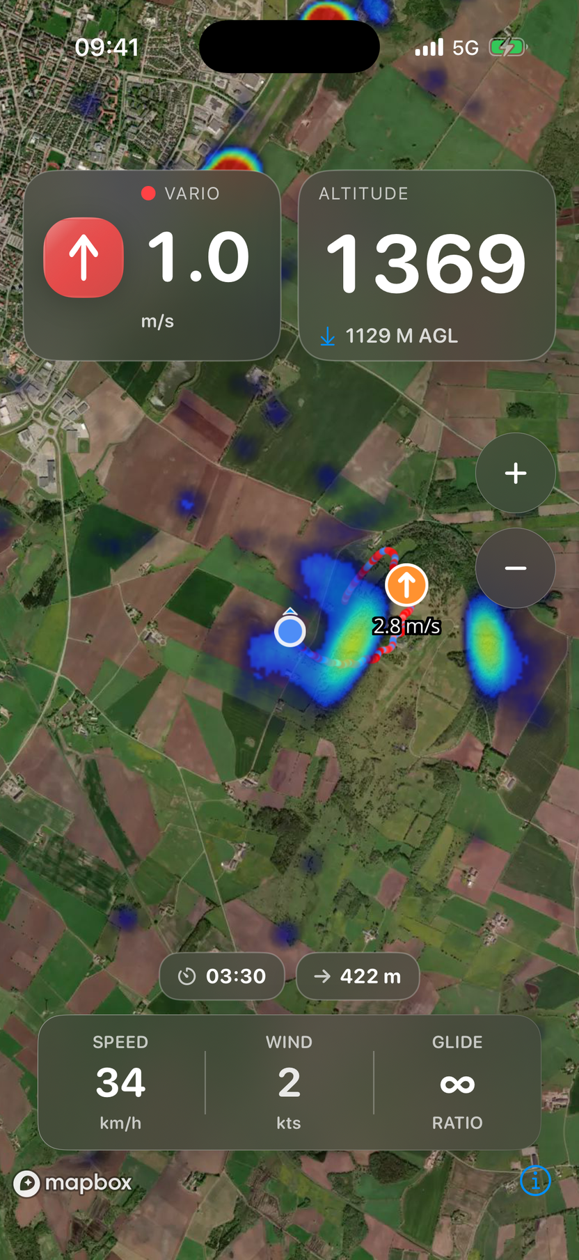
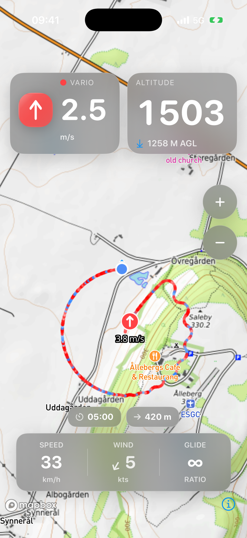
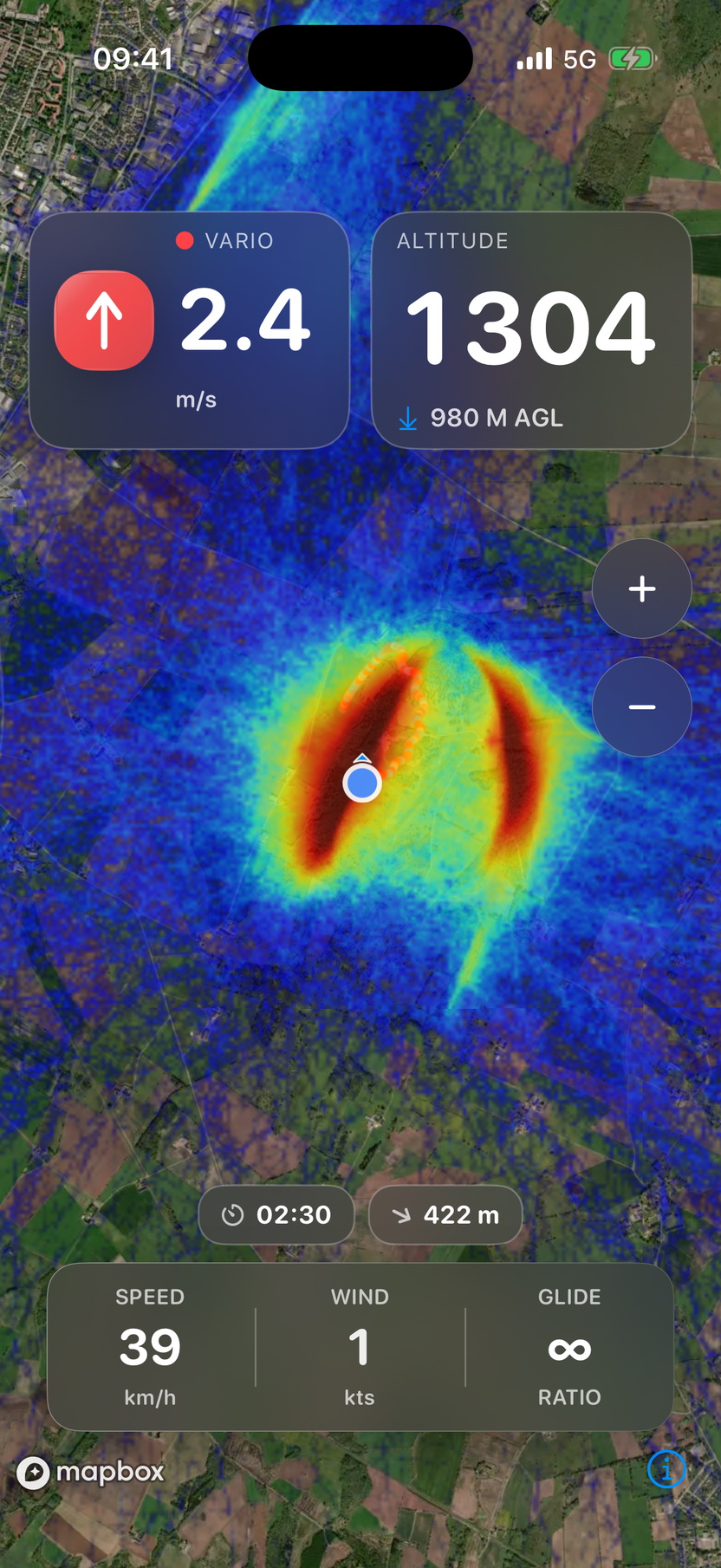
VarioBud showing a live thermal heatmap over satellite imagery — vario climbing at 0.9 m/s, altitude 1374 m, ground speed 39 km/h, plus wind and glide ratio

In the air

Everything a free-flight pilot needs

VarioBud turns your phone into a full flight instrument — pairing with your Bluetooth variometer and layering live thermals and airspace on the map.

📈

Real-time flight data

Vario, altitude (MSL & AGL), ground speed, wind and glide ratio — big, glanceable numbers that read at arm's length in flight.

🛰️

Bluetooth variometer

Pairs with LK8000-compatible, NMEA and BlueFly devices — LK8EX1, LXWP0, GPGGA, GPRMC — and reconnects on its own when your vario comes back.

🧭

Lift / sink trail

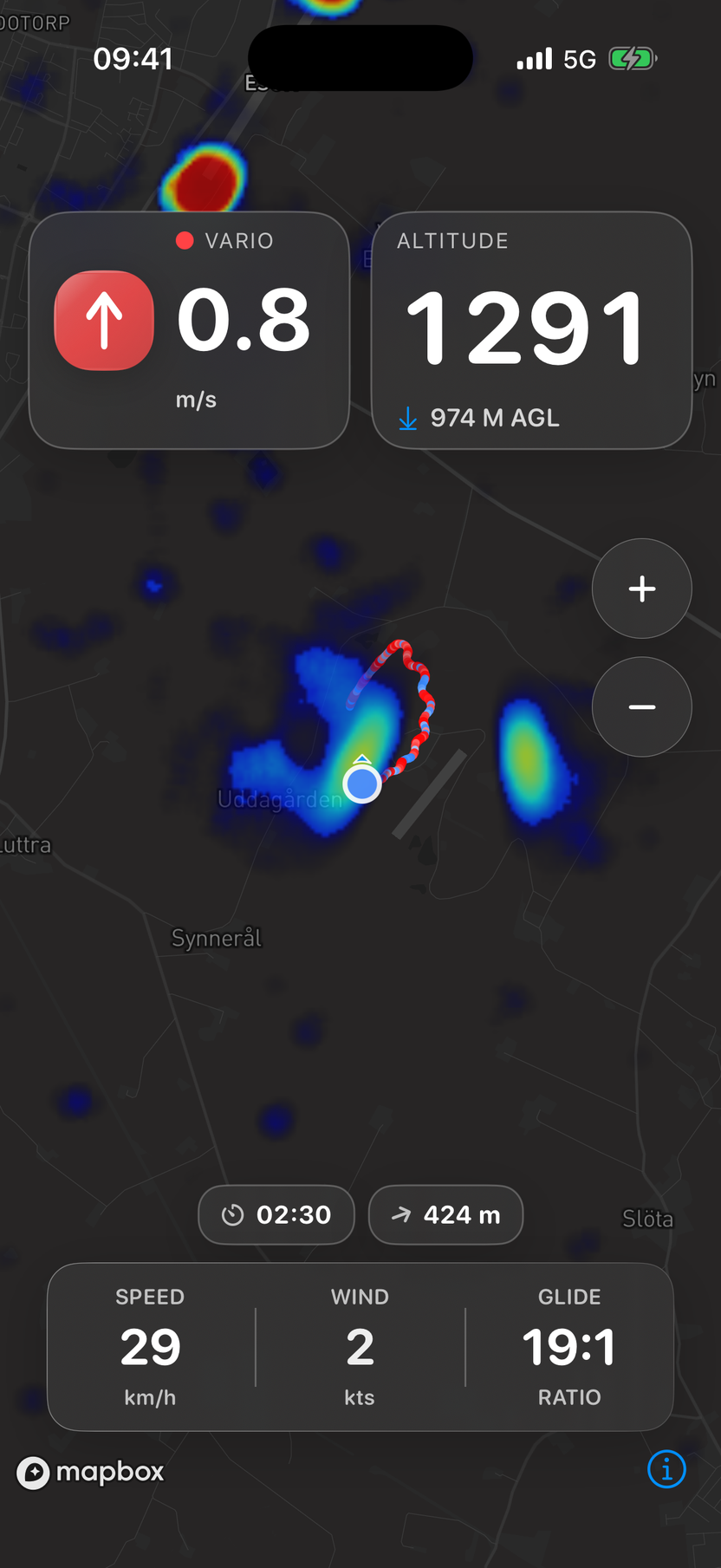
Your last ten minutes drawn in red for climb, blue for sink — and lift zones labeled by strength, from weak to exceptional.

🌡️

Live thermal overlays

Thermal probability maps from thermal.kk7.ch with adjustable opacity, right on top of your map.

⚠️

Airspace on the map

Color-coded zones — prohibited, restricted and controlled — with proximity alerts. Download the countries you fly and that airspace stays available with no signal.

📓

A flight log that keeps itself

It starts at takeoff and ends when you land, so the flight time is the flight rather than whenever you remembered to stop it. Your last flight and full log greet you on the home screen, and the IGC file is written the moment you are down — signed, and waiting in Files.

📡

Live tracking

Stream your position to LiveTrack24 so friends and retrieve can follow along — it queues through dead zones and backfills when coverage returns.

💨

Wind, without a wind sensor

Thermal for a couple of turns and VarioBud reads the wind off your own drift — speed and direction, no extra hardware. It stays put on the glide instead of twitching, so you can trust it when you pick your line.

☀️

Built for sunlight

A high-contrast outdoor mode, plus controls that slide out of the way when you're not using them, keep your eyes on the sky.

Turn it sideways

More map, and every number still in view

Most pilots fly with the phone on a leg mount, turned sideways. VarioBud uses that shape: your instruments run down the two edges, where your thumbs already are, and the map gets the whole middle.
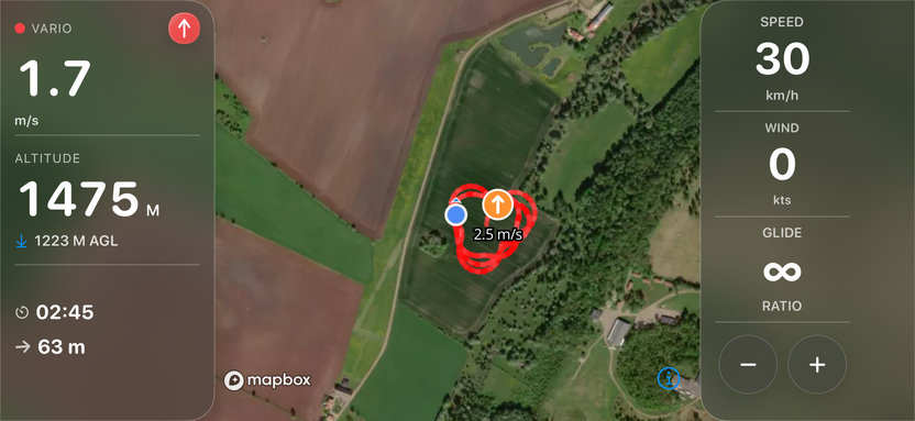
VarioBud in landscape: a panel down the left edge showing climb rate and altitude, a panel down the right edge showing ground speed, wind and glide ratio with the zoom buttons at its foot, and satellite map filling the space between them

Seven styles, two overlays

Your map, your way

Satellite, topographic, outdoors, streets, light and dark — seven base styles with live previews in the picker and 3D terrain on most. Layer thermal probability or skyways on top, at whatever opacity you like.
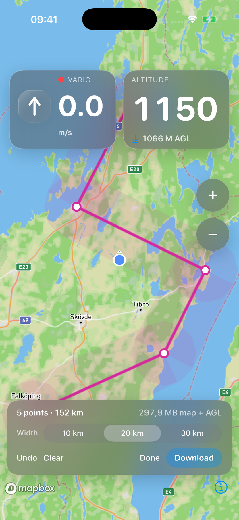
VarioBud planning a 152 km route across southern Sweden — five waypoints tapped onto the map, the line joining them, and the shaded strip of map either side that will be saved to the phone, with the distance and the download size shown along the bottom

Before you fly

Draw a route, or scan someone else's task

Tap out where you plan to fly, and VarioBud keeps that strip of map on your phone. Deep in a valley with no signal, the map is still there — and so are the fields you might need to land in.

  • A task set somewhere else comes straight in. Point the camera at the QR code on a competition task board, pick one out of a photo, paste an XCTrack or flyxc link, or open a .xctsk file. You see what it read before you accept it.
  • Then fly it. The map shows the next turnpoint, how far you are from tagging it, and which way to turn — relative to the way you are already going, not to north.
  • It works where the signal doesn't. The ground along your route is already on the phone before you launch. No bars needed — and no downloading a whole country to get it.
  • Landing options when you need them. Close enough in to pick a field, the whole way round the route, not just near launch.
  • Your height above the ground keeps working. The terrain comes down with the map, so the number telling you how much room you have is still right out on course.
  • Keep your home site. Mark the hill you fly most as your home site and it stays on the phone beside whatever task you load next: its map, the terrain for twice the width, and its airspace.
  • You see the size before you commit. Every map download shows its size first, and a map overview checks there is room on the phone before it starts. Maps are kept up to 30 days, the limit the map licence sets; the ones for your task and home site renew themselves on Wi-Fi while VarioBud is open. Map overviews renew while VarioBud is open and the phone charges on Wi-Fi.

Know the airspace

Airspace, drawn to be read at a glance

Every zone drawn in a color you can read at a glance — red for prohibited, orange for restricted, blue for controlled — with the zone at your position highlighted in cyan.
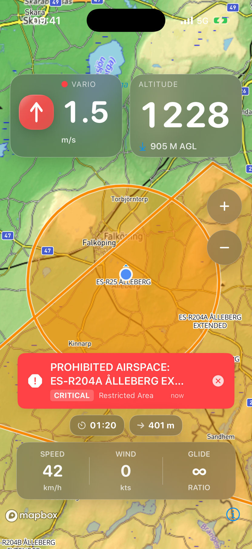
  • Warnings that escalate. A heads-up when you're within 2.5 km of a restricted zone, a critical banner when you're inside one — and critical warnings never dismiss themselves.
  • Altitude-aware. A zone whose floor is far above you stays quiet. Warnings only fire when you're actually in its altitude band.
  • Tap any zone for its class, authority, altitude limits and contact details.
  • Works offline, anywhere. Download any country in the world before you travel — search for it, tap it, and it is on the phone, with a coarse map overview of it if you want one. Airspace for the country you are in downloads by itself when there is a signal — usually a megabyte or two — and waits for your tap in Low Data Mode. Map and terrain downloads wait for Wi-Fi unless you tap to use mobile data; airspace, and the terrain tile under you in flight, use any connection.
VarioBud showing the Ålleberg restricted zones in orange with a critical restricted-area warning banner

Three steps

From launch to landing

1

Connect your vario

Pair your Bluetooth variometer in seconds. VarioBud remembers it and reconnects when it sees it again.

2

Fly with live data

Watch vario, altitude and glide ratio update in real time while thermals and airspace sit live on the map.

3

Read the air

Follow your color-coded lift/sink trail back to the strongest climbs and fly your best line.

No vario connected? VarioBud can still use your iPhone's GPS to show your position on the map.
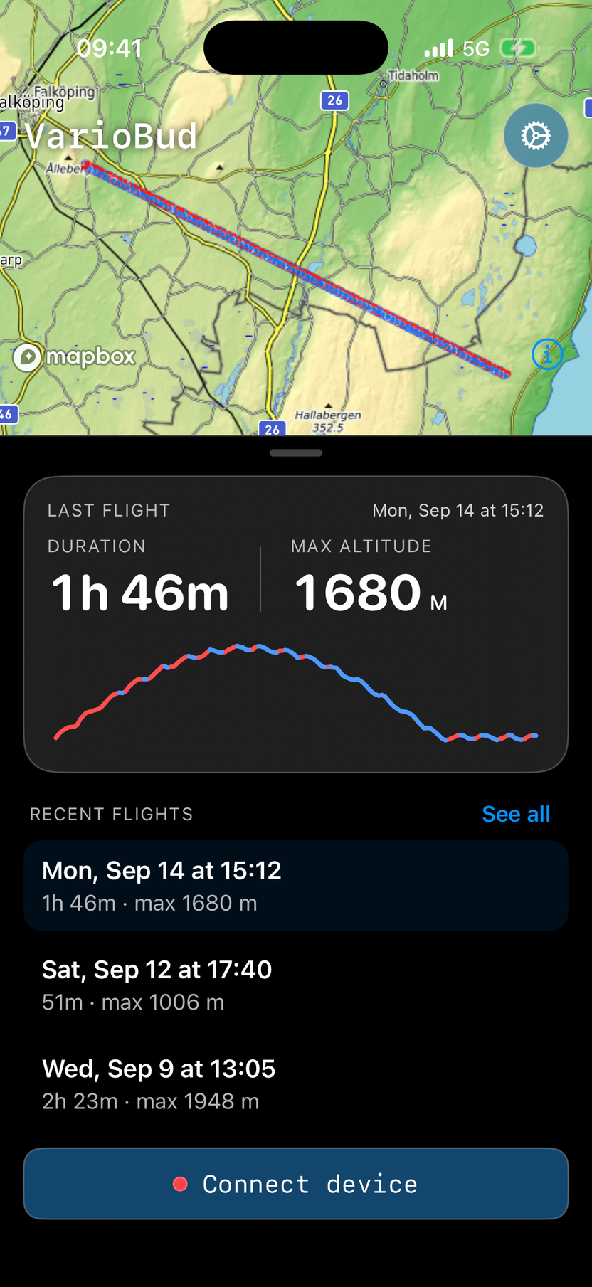
VarioBud home screen — last flight of 1 h 46 min with max altitude 1680 m and an altitude profile, floating over the map with the recorded track drawn on it, above the recent flights list

On the ground

Every flight, remembered

Land, and your flight is already in the log — takeoff detection starts the recording, one fix per second, IGC-style, and landing detection ends it.

  • Greets you at launch. The home screen opens on your last flight — its track drawn on the real map, duration, max altitude and full climb-and-sink altitude profile.
  • It knows when you are down. The flight closes itself at touchdown, so the time you see is the time you flew, and the IGC file is written there and then rather than when you remember to ask for it.
  • Crash-proof. The track checkpoints to disk as you fly — a dead battery costs you a couple of minutes of trace at worst, never the flight.
  • Yours to take. Every flight is a standard IGC file, carrying the G-record signature contests look for, ready for your logbook, league or coach. Pick it up in Files under VarioBud → IGC, or share it straight from the app.

Engineered to sip

Built for six-hour days

A flight instrument is only useful if it's still on at landing. Battery-optimized mode ships on by default and is tuned from real-flight power measurements.

30 → 60 fps

Adaptive frame rate

The map idles at 30 fps and jumps to a full 60 the moment your finger touches it — panning, zooming and the fly-in always run smooth.

0 wasted frames

No decorative churn

Effects that force the map to redraw every frame, like the pulsing location ring, are off by default. Turn them back on if you like — it's one switch.

10 s

Radio discipline

Bluetooth scanning stops itself after ten seconds, uploads batch instead of trickle, and network retries back off in dead zones instead of hammering.

Awake in flight

Screen when it matters

The display stays on only while your vario is connected — you can't tap to wake mid-flight. Browsing maps on the ground, it sleeps as normal.

iPhone · iOS 17.2+ · Works with LK8000-compatible, NMEA & BlueFly variometers · Paragliding · Hang gliding · Soaring

Your flight, your data

VarioBud uses your location only to show your position and track your flight, and Bluetooth only to read your variometer. There are no accounts, no analytics and no ads — and nothing is ever sold or shared. Your settings stay on your device.

Read the privacy policy

Get in touch

Made by Karla Digital

gustav@variobud.com

VarioBud is an independent project, built by a pilot for pilots. We'd love to hear from you.